First: the weather --- see: http://weather.gc.ca/marine/region_e.html?mapID=02 (general PNW) and
http://weather.gc.ca/marine/forecast_e.html?mapID=02&siteID=14301 (North of Nanaimo)
Then: The following charts are useful / needed for the trip from Cowichan Bay into the Broughtons:
3312 Jervis Inlet & Desolation Sound and Adjacent Waterways/et les voies navigables adjacentes
3462 Juan de Fuca Strait to/à Strait of Georgia
3463 Strait of Georgia, Southern Portion/Partie Sud
3538 Desolation Sound and/et Sutil Channel
3512 Strait of Georgia, Central Portion/Partie Centrale
3513 Strait of Georgia, Northern Portion/Partie Nord
3539 Discovery Passage
3543 Cordero Channel
3544 Johnstone Strait, Race Passage and/et Current Passage
3545 Johnstone Strait, Port Neville to/à Robson Bight
3546 Broughton Strait
This charts are available through the Canadian Hydrographic Services, however, can only be bought through retail business. CHS does not sell charts directly to the public.
More info on electronic charts for tablets and laptops: My research showed that both Navioniks (vector charts) and Memory Map (raster charts) charts are of similar costs like paper charts in Canada, because the Canadian Hydrographic Service has a de facto monopoly on the official charts.
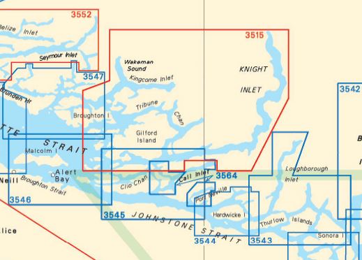
Icons of most of above's charts:


http://weather.gc.ca/marine/forecast_e.html?mapID=02&siteID=14301 (North of Nanaimo)
Then: The following charts are useful / needed for the trip from Cowichan Bay into the Broughtons:
3312 Jervis Inlet & Desolation Sound and Adjacent Waterways/et les voies navigables adjacentes
3462 Juan de Fuca Strait to/à Strait of Georgia
3463 Strait of Georgia, Southern Portion/Partie Sud
3538 Desolation Sound and/et Sutil Channel
3512 Strait of Georgia, Central Portion/Partie Centrale
3513 Strait of Georgia, Northern Portion/Partie Nord
3539 Discovery Passage
3543 Cordero Channel
3544 Johnstone Strait, Race Passage and/et Current Passage
3545 Johnstone Strait, Port Neville to/à Robson Bight
3546 Broughton Strait
This charts are available through the Canadian Hydrographic Services, however, can only be bought through retail business. CHS does not sell charts directly to the public.
More info on electronic charts for tablets and laptops: My research showed that both Navioniks (vector charts) and Memory Map (raster charts) charts are of similar costs like paper charts in Canada, because the Canadian Hydrographic Service has a de facto monopoly on the official charts.
Icons of most of above's charts:


